
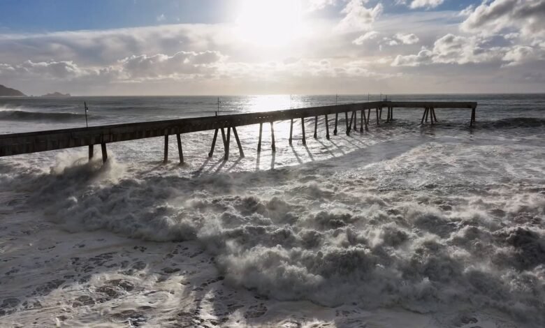
Waves above 50 feet crashed into the shore in San Mateo County in California over the weekend. Shorefront yards in Mission Beach in San Diego filled with seawater. Families were swept off their feet by a wave overtopping a berm at Orange County’s Seal Beach. These were just some of the scenes along the California coast as hurricane-force winds offshore combined with already exceptionally high sea levels to send the ocean surging onto land.
But they’re a small taste of what could be in store as the annual king tides loom against the backdrop of an exceptionally strong El Niño this year. The combination could bring substantial damage to coastal homes, businesses and infrastructure, such as highways and wastewater treatment facilities. And coastal erosion in California could be considerable, given that 80 percent of erosion occurs during El Niño winters, says Christina Richardson, a University of California, Santa Cruz, coastal hydrologist.
Coastal flooding is “going to be a big problem—a very, very big problem,” climate scientist Daniel Swain, a climate scientist at University of California Agriculture and Natural Resources, said in one of his recent YouTube briefings.
On supporting science journalism
If you’re enjoying this article, consider supporting our award-winning journalism by subscribing. By purchasing a subscription you are helping to ensure the future of impactful stories about the discoveries and ideas shaping our world today.
Sea-Level Stacking
The reason sea levels have been at record-breaking highs—and will continue to be so for the next few months—is that several threats are stacking on top of each other.
First is the background sea-level rise fueled by human-caused global warming, which has added between four and nine inches to sea levels over the past century, depending on the location. That rise means that all tides are permanently higher than they would’ve been in the past.

Amanda Montañez; Source: Christina Richardson, University of California, Santa Cruz (reference)
On top of that are contributions from El Niño, which is currently shattering records and could be the strongest such event in the past 1,000 years. An El Niño happens when warm ocean waters shift from the western to the eastern tropical Pacific. Those waters can work their way across the ocean basin in big blobs called Kelvin waves—when those waves hit the coast of South America, part of the water migrates northward, raising sea levels along the U.S. West Coast.
These Kelvin waves have strengthened a marine heat wave that was already in place along the California coast and has reached truly astonishing temperatures. “I’m almost at a loss for words because it’s more than 10 degrees Fahrenheit warmer than average in places like San Diego, Santa Barbara, even Monterey Bay—the Farallon Islands, for crying out loud,” Swain said in his video. Temperatures around the Farallons, just to the west of San Francisco, usually decline this time of year. Instead they’ve been steadily rising.
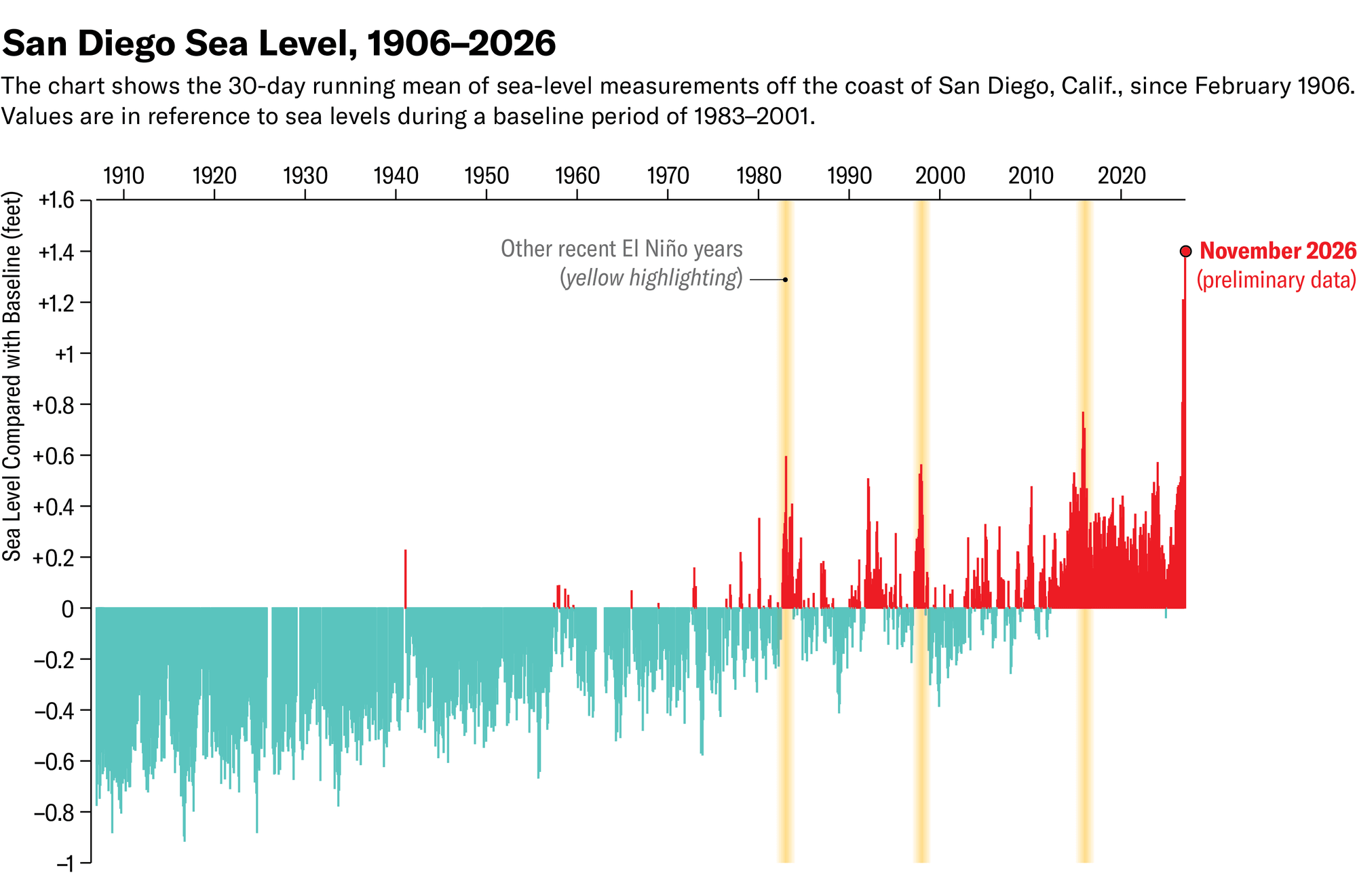
Amanda Montañez; Source: Mark Merrifield, University of California, San Diego (data)
All that extra warmth causes thermal expansion, which has added another six to 20 inches to sea levels, depending on the exact location. “We’ve never seen water levels this high” in San Diego, Mark Merrifield, a University of California, San Diego, oceanographer, said during a recent press briefing.
King Tides and Storms
And there are the king tides.
“King tides are really just an informal name for the highest predicted astronomical tides of the year,” Richardson says.
Basically, the gravitational pull from the sun and the moon cause bulges in the ocean that travel around the world and cause the monthly tidal cycle. High tides peak twice a month when Earth, the moon and the sun are in near alignment. But every 28 days, the moon is at perigee, or the closest it gets to Earth in its elliptical orbit, so it exerts even more of a pull. When perigee aligns with the monthly high tide, you get king tides.
The first set of king tides in California will be from November 24 to 26. They will occur again on December 23 to 25 (when they will be even higher) and on January 21 to 22.
High tides in late October already caused major damage, flooding homes and businesses in low-lying areas around San Francisco, breaching berms and walls of sandbags in Newport Beach and rendering six homes in Orange County unsafe for habitation. The coming king tides will be half a foot to a foot higher, so those dates are “periods of very high concern for widespread and potentially significant—maybe even record-breaking—coastal flooding,” Swain said in another recent video.
If a storm happens to align with the king tides, the destruction will be even worse as storm surge and high waves get added to sea levels. And even if storms come in between those tidal peaks, they could cause considerable damage. For example, with El Niño alone, the San Diego area is predicted to have 25 days before the end of this year with a sea level above what is normally a king tide and 10 days with seas above the October flood level, Merrifield said.

Amanda Montañez; Source: Mark Merrifield, University of California, San Diego (data)
The king tides could also bring flooding beyond the coast as they seep into bays and even estuaries, Swain warned.
For those who could face the coming tidal onslaught, “it’s still not too late to prepare,” Richardson says. Residents should make sure they have backup power for their sump pumps; many communities are giving out sandbags. She also advises people to understand the particular risks where they are—for example, the exact risks might be different right on the beach versus up an estuary.
Whatever the coming months bring, they will also serve as “a preview of what’s ahead of us,” she says, with even more climate-change-driven sea-level rise to come, underscoring the need to adapt now.
Source link