
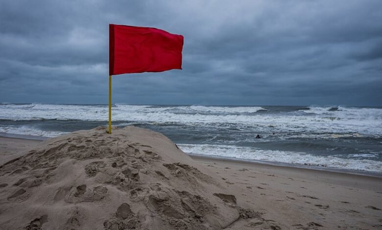
Hurricane Erin made its closest approach to the tristate late on Thursday, delivering dangerous rip currents, rough surf, and coastal flooding along our shores. Conditions will improve as we head toward the weekend, but we’ll continue to see residual impacts from Erin at the coast, so swimming at the beach will remain dangerous due to the high rip current threat. Fortunately, though, skies will be brighter and temperatures will be warmer for those of you who want to dig your toes in the sand.
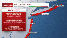
The rip current risk has been high all week, even leading to the closure of some area beaches. And we’ll see that high risk persist through at least Friday, if not Saturday. The rip currents are strong enough to carry out even the most experienced swimmers. Stay out of the water as long as we continue to face a high threat for dangerous rip currents, even if there is a lifeguard on duty.
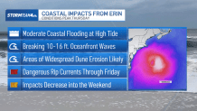
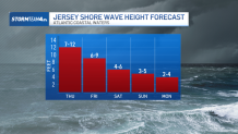
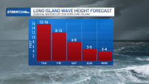
We saw surf zone wave heights peak on Thursday, where eastern Long Island beaches saw waves up to 16 feet. Surf won’t quite reach the same heights on Friday, but we’ll continue to face high surf conditions across both New Jersey and Long Island, where waves could still reach heights upwards of 10 feet. Surf heights will continue to go down day by day, but even by Saturday, we could still see waves well above what is usual for our coastal spots. It won’t be until Sunday into Monday that we’ll really see the sea settling.
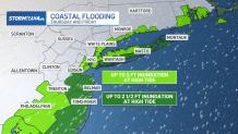
On top of impacts within the ocean, Erin also kicked up some brisk easterly winds contributing to moderate levels of coastal flooding Thursday night, where we saw inundations in low-lying areas up to 2 ½ feet. As Erin continues to move further north and east, away from our area, its influence on the strength of our onshore winds will diminish, but we’ll continue to see the effects through Friday, though not quite to the same degree. Thursday’s coastal flood warnings will go down a level of an advisory on Friday, though flooding in especially vulnerable areas could still reach up to 2 feet.
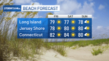
But even as we continue to see lingering effects from Hurricane Erin, making it difficult to enjoy time in the ocean, weather conditions will grow increasingly favorable as the weekend goes on for a day spent out on the sand. High temperatures will be back up into the 80s for most of us as we enjoy a run of days with low humidity, light winds, and sunny skies. Even the upcoming rain chances we are watching for Sunday won’t bring much impact to our coastal areas. And the areas that do see rain won’t get any until late Sunday night.
So we may still be in the throes of Erin’s influence for now, but the worst is behind us. Coastal conditions will slowly start to improve and just in time for a gorgeous weekend. You’ll want to get outside and enjoy it while you can; summer days are fleeting… and Labor Day is a little over a week away.

Source link