
The final in our series of East Coast storms is headed our way this weekend. And it could be the one with the biggest impact. We’re tracking a mix of snow, ice, and rain that’ll make for a wintry Saturday and sloppy Sunday.

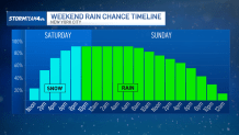
If you need to run any errands this weekend, get them done early on Saturday. Saturday morning is the only time this weekend that will be dry, with roads unencumbered by ice or slush.
Things go downhill beginning Saturday afternoon. Precipitation will start to push into the region around lunch time. And it will be cold enough at the onset to support snow area-wide. Temperatures will slowly rise through the day and into the evening, and the snow will switch over to a wintry mix and eventually all rain.
South Jersey will be the first to transition to all rain, generally by early evening. For the city, we’ll hold onto the snow through dinner before quickly changing over to rain late Saturday night.
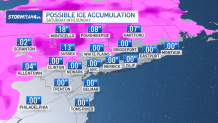
The Hudson Valley will get snow until around midnight. After that, the snow will transition to rain, but it’s largely going to be freezing rain. This is rain that falls as liquid, but immediately freezes on contact, turning surfaces to a sheet of ice. It’ll also form a hard, icy shell around the snow on the ground; it is not going to be a fun digging out when this event is over.
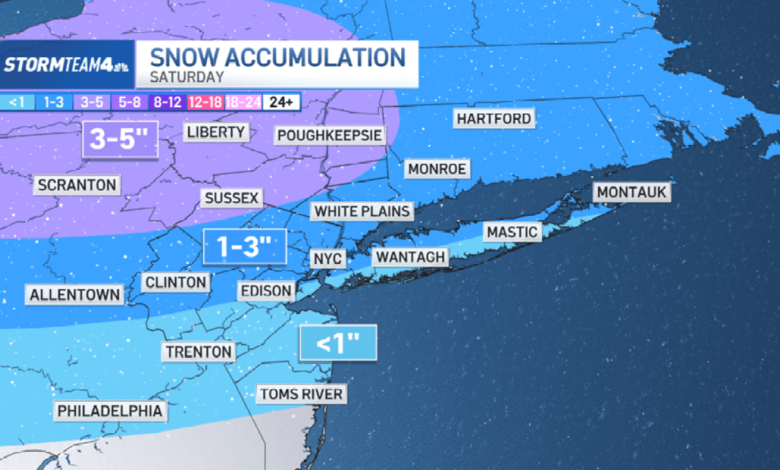
Generally, the quick changeover to rain in conjunction with relatively milder temperatures will make for more diminutive snow totals down the Jersey Shore; expect less than an inch. Across the rest of the area, most of the us can look forward to an additional 1 to 3 inches of snow. But in the higher elevations, especially up into the Poconos and the Catskills, accumulations will trend higher, more on the order of 3 to 5 inches.

Through the day on Sunday, most of us are dealing with the continuing rainfall. This will turn much of the previous day’s snow into slush, leaving sidewalks and roads slippery and sloppy. If you plan on heading outside, the rain or snow boots are going to be essential. By the evening, showers finally begin to taper as our storm system moves off shore.
Totaling it all up, the rain, snow, and ice will account for about 1 to 2 inches of liquid equivalent precipitation, with about half an inch to an inch of that falling as rain.
Source link